Norwegian Broadcasting has started to release high quality episodes of their show Nordkalotten 365 on bittorrent. As near as I can tell from the first episode, the show is of Lars Monsen, who seems to be some sort of Les Stroud type of fellow, filming himself during wilderness travels in Norway. Suffice to say, he punches a few fish. And the theme song seems to be a remix of the theme from The Good, The Bad, and the Ugly.
While not growing beards to spite The Man™, those of us of the XY variant must adhere to a regiment of shaving. Up till about a month ago, I’d always used an electric shaver. (How they work is beyond me. You can take the thing apart and there’s not one sharp object in it. It’s as if they just vibrate the hair to death, perhaps combining that a verbal threat or two, all of which seems little better than rubbing an electric dildo along one’s face.)
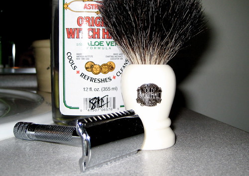
About a month ago, then, I switched to a double-edged safety razor, modeled after Gillette’s 1901 invention.
Initially, I also went with an unscented soap cake, but the back of the packaging listed ingredients that I couldn’t pronounce (never a good sign), so I switched that out for a bar of locally made goat milk soap. It doesn’t provide such a thick lather as the shaving soap did, but seems to work just as well in all other respects.
I was worried about cuts and burns a good deal at first, having heard many horror stories from those who switch between electric shavers and the new-fangled-triple-bladed-cheap-plastic-crap razors. To my surprise, there was none of that. My skin has not complained, nor have I managed to place a cut.
The process, detailed below, takes me roughly 20 minutes. Certainly much longer than an electric shave, but adds to the act a sort of timelessness – though the double edged razor was only invented a century ago – and elevates it to ritual. It is an act of meditation, an escape from the mundane – the repetitive, brain-dead, electronic processes of our time. It is moment unto itself, not merely a pause or interlude till the next scene. Instead, something to be planned for, to be appreciated, and to look forward to, and that, in the end, is what truly matters.
Procedures for the Operation of a Double Edged Safety Razor
(It is assumed that the following is completed after stepping out of the shower, as a face soaked in warm water is the first requirement.)
Fully dampen your badger hair brush by holding it under a stream of warm-to-mildly-hot water, perpendicular to the flow, and slowly twisting it. After it seems to be fully soaked, remove the brush from the water and turn it parallel to the stream, so that the bristles are pointed down. Allow excess moisture to drip out, taking care not to flick or otherwise encourage any additional water to drip than the brush is willing to give on its own.
Now that the brush is only dripping the occasional, non-continuous drop, move it to your soap dish/mug. Gently move the brush about atop the soap, in a circular motion, applying little pressure and taking care to not circle too vigorously and flick off any additional moisture. The objective here is not to generate a lather on the soap, but to gather soap in the brush's hairs. If a lather does begin to develop within the dish, the brush has enough soap. I circle for about 30 seconds.
Bring the brush to your face and begin to circle in a wide motion around the area to be shaved. Apply only gentle pressure. Here, you are attempting to build up a lather, but patience is required: it may take up to 2 minutes for a sufficient lather to develop. (It usually takes me about a minute). After the lather has achieved the desired covering and consistency, place the brush into the soap dish.
Now, bring the razor to your face. The objective is to run the razor down the lather-covered area (from top to bottom, or north to south), applying no pressure, whilst maintaining a 30° angle to the skin. I prefer long strokes along the face, but resort to short strokes around the contours of the neck and chin. To start, it is easiest to place the razor's safety bar perpendicular to the skin and raise it slowly till the desired 30° angle is achieved. Then, begin the stroke.
The first pass having now been completed, it is likely that a second is wanting. A second lathering may be required, though I omit this step. On this second pass, the stroke should be from bottom to top, or south to north.
With these two passes complete, any remaining patches of stubble may be removed with a diagonal stroke
The shave now being complete, I finish up with a splash of cold water on the face, which, I'm told, closes the pores (and provides opportunity to remove any excess soap), and pat my face dry.
As an aftershave, I only splash my face with a bit of Witch Hazel in liquid form.
For the clean up, the badger hair brush should be thoroughly rinsed and dried. The razor gets a rinse, though a complete disassembly is only required once a week when the blade is changed.
The Wednesday before last I managed to fracture a rib at Fight Club. It failed to make itself known during class – only later did I inventory a small, sharp pain upon taking deep breathes. My journal that night accounts:
1-2-08 10:12 PM
It hurts when I breath.
Is that bad?
Thinking nothing of it, I returned to class on Thursday, which proved to be a mistake, the pain after that night being far greater. At this point, I decided that something was not quite right. My next journal entry reads:
1-4-08 8:10 PM
My self-diagnosis is that I have a fractured rib. It is either the 2nd or 3rd rib (or both) down from the top on my right side. I don't think it anything serious: my breathing is even, at a normal cycle and depth, and (as near as I can tell) there are no abnormal sounds. This leads me to believe that it is a minor fracture, not a break, and that the lung has not been punctured by a stray splinter.
Deep breaths are painful, but not so much as to discourage them. Certain obtuse movements of the right arm, as well as twisting of the torso, causes pain. The most painful act is bending over to tie my boots -- methinks it is gravity dropping all my guts and exerting pressure onto the rib. I now kneel instead. I have yet to cough.
Consulting the medical books I have lying about (and the global interwebs), the only treatment for such an ailment proved to be observing a minimum of one deep breath an hour and a strict rest cure, to last till the rib was healed, which on average takes 2-3 weeks. Clearly, this would not do. A month absent from Fight Club would be regrettable, but a month without running or riding my bike or any other activity that involves frequent deep breaths would not be possible (though the pain was not enough to discourage my normal cycle and depth of breathing, what was previously aerobic had become anaerobic and what was anaerobic was right out). As such, I decided to alter my diet in an attempt to assist the healing process.
Calcium & Silica
Of course, it is common knowledge that bones need Calcium to grow. I dislike milk, but instead increased my intake of almonds, broccoli, carrots and salmon; all of which are rich sources of the mineral. For teas, I purchased Horsetail and Nettle, to supplement the Alfalfa and Chamomile which I already had. Horsetail and Nettle, it just so happens, are also a source of Silica, which, I’ve read, aids in the proper assimilation of Calcium.
Magnesium & Vitamin D
But, surely, Calcium is not all that is required? Further research indicated that both Magnesium and Vitamin D intake should be increased when consuming more Calcium. And what herbs provide an ample source of both Magnesium and Vitamin D? Why, Alfalfa, Horsetail, and Nettle, of course! It’s almost as if Mother Nature knows what she’s doing. Food sources of Vitamin D include egg yolk, salmon, and sweet potatoes. Food sources of Magnesium may be seafood, apples, bananas, brown rice, and salmon.
Phosphorous & Copper
Care should be taken to increase the amount present of two other minerals, as well: Phosphorous and Copper. Eggs and salmon, it turns out, are excellent sources of Phosphorous. Copper may be acquired through almonds. (Side note: I’ve discerned that it is not possible to kill oneself by eating too many sprouted almonds. If it were, I surely would be dead by now.)
Results
So my diet changed to consist of much salmon, brown rice, carrots, apples, bananas, broccoli, with the odd sweet potato and a hard boiled egg once a day. Whenever I felt the need to munch on something, I’d toss down a handful of sprouted almonds (as I’m doing right now). Each morning I would have a cup of Nettle tea, each night a cup of Horsetail tea. If I felt the desire for tea in the middle of the day, I would mix together a bit of Chamomile with a bit of Alfalfa.
All said and done, the rib healed in a week and a half.
Did my diet influence that? Well, diet couldn’t not influenced the body, but as this is the first time I’ve fractured a rib, I’ve no bench-line against which I can measure; save only that the Medical Establishment deemed 2-3 weeks an appropriate number to publish here and there. It certainly didn’t hurt.
(Food and herbal sources of vitamins and minerals were all gathered from the CedarLily Vitamin & Mineral chart that John Gallagher used to sell.)
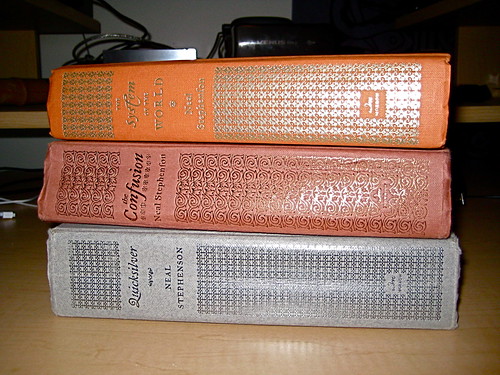
After re-reading Neal Stephenson’s The Diamond Age last November, I had an inkling to do the same with The Baroque Cycle, Stephenson’s tome on Alchemy, Economics, Technology, and an agreeable amount of Swashbuckling in the late 17th and early 18th centuries. It is an account of the birth of our modern world-system.
Quicksilver and The Confusion I first read when they were published, but at the time The System of the World was released, I was distracted by other ruminations. By the time I was free, I felt too much time had passed since my experience with the first two books, so I never read the third. Now, I intend to read them back-to-back.
Quicksilver I finished in a week and half. The Confusion I’ve been reading for near the same amount of time and am roughly halfway through, though I fear it will take longer to complete. Allowing for (un)necessary distractions, I should like to finish the cycle by the end of February.
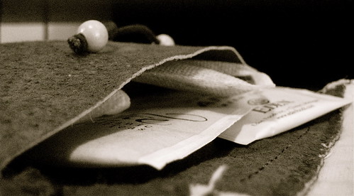
This leather pouch joins me on all my travels. Despite popular belief, it does not hold plant remains of a questionable legality, but instead carries what tea I’m inclined to treat myself to during the current spell of vagrancy. Current contents are kukicha, green tea, and a mix of loose leaf herbal from Mountain Rose – Peppermint, Chamomile, Gotu Kola, Mugwort, Damiana, Rosemary, Rose Petals, and Stevia, if we’re naming names.
Judge rules defendant can’t be forced to divulge PGP passphrase
A federal judge in Vermont has ruled that prosecutors can't force a criminal defendant accused of having illegal images on his hard drive to divulge his PGP (Pretty Good Privacy) passphrase.
U.S. Magistrate Judge Jerome Niedermeier ruled that a man charged with transporting child pornography on his laptop across the Canadian border has a Fifth Amendment right not to turn over the passphrase to prosecutors. The Fifth Amendment protects the right to avoid self-incrimination.
Niedermeier tossed out a grand jury's subpoena that directed Sebastien Boucher to provide "any passwords" used with the Alienware laptop. "Compelling Boucher to enter the password forces him to produce evidence that could be used to incriminate him," the judge wrote in an order dated November 29 that went unnoticed until this week. "Producing the password, as if it were a key to a locked container, forces Boucher to produce the contents of his laptop."
Steampunk: a history that wasn’t quite. At once both Victorian and Dystopic. A world filled by brass gears, pin-stripe suits, and a steam powered Deus ex Machina.
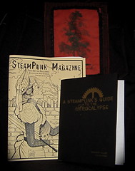
I’ve been familiar with steampunk as both a literary spin-off of cyberpunk and as a modding community, but only recently – through SteamPunk Magazine – come into it’s aberration as a subculture.
This third issue of SteamPunk Magazine is my first. I found it to be a most delightful mixture of short-fiction, interviews, tutorials, and rants. My preferred rant was My Machine, My Comrade by a one Prof. Calamity, in which he sees steampunk as “seeking[ing] to liberate the machine from simply existing as an instrument of work, while at the same time not elevating mechanical forms above all else… Steampunk seeks to find a relationship with the world of gears, steel, and steam that allows machines to not only co-inhabit our world but to be partners in our journey.” My favorite fiction was Margaret P. Killjoy’s Yena of Angeline in “Sandstorms by Gaslight” which (very much like mine own fiction) seems to go nowhere. It has no direction, and does not leave its reader with a sense of anything being accomplished, which makes it a disappointing first read. But, again and again, I find my mind wandering back to the world that Killjoy crafted and the characters that inhabit them. Ant that, I think, is some element of praise.
A SteamPunk’s Guide to the Apocalypse is a survival manual of sorts, covering basic aspects of shelter, water, and food. It should provide nothing new to the established crazy and serves as no replacement to In the Wake (or any of the works listed in the Guide’s Appendix B), though features thoughts on reclaiming urban resources that are lacking in other guides. But, like In the Wake, it is available as a free download, thus nullifying any excuse to not peruse the contents and keep it as a handy reference. I purchased it partly to support SteamPunk Magazine, but mostly for Colin Foran’s artwork, which provides a wonderful backdrop to the gritty subject of post-Civilization apocalyptic survival. Beyond comparisons to other manuals for outliving Civilization, my main criticism is that of the style of writing. Writers in the Victorian era were much more liberal than us in their use of capitalization, but there was a system. When I read those works, I feel the capitalization adds a certain emotion to the writing. Being a SteamPunk’s Guide, the author of this work (by happenstance, the same Margaret Killjoy whom I praised above) attempted to duplicate this capitalization, but failed. Whether there was or was not a system, it feels arbitrary, and detracts from the overall work. The Guide does present an attempt to emulate that era’s vocabulary, and I think does a good job of that – combining a sense of Victorian grace with modern punk and a bit of wit, for an agreeable solution of steampunk.
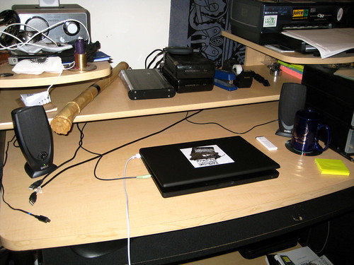
I’ve been inspired by the Unclutterer Flickr pool, of late. After discovering an over-due power bill buried under the liter on my desk, I decided it might be time for a cleaning.
One uncovers a number of artifacts from amidst the numerous papers. Writings of Hakim Bey, a copy of the the Canon of the Roman Catholic Mass, WPA attacks, The Laws of Manu, a not-yet-expired Montana fishing license (or “conservation license”, as they would have), crypto algorithm discussions, lockpicking guides, a zine about bikes, a song book for an Ocarina, those fake press badges I got in Bangkok, satellite photos of UPS’ local warehouse (I don’t even remember why I have those)…
It still needs work, but the space has improved, and it does a deal of good for the mind.