My bike entered into an argument with a set of train tracks today. In a bit of a Snidely-Whiplash-moment, I took a nasty spill on said tracks. No damage to me, thanks to a helmet, gloves, and, most importantly Revision Sawflys.
I conked the side of my face pretty good. There’s no doubt that if I’d been wearing my normal glasses, there would have been scratched lenses, snapped frames, and I probably would have lost one of those damned little screws, too. But with the Sawflys? Not a scratch! (No screws to loose, either.) Had I no eye-wear at all? Well, I probably would have gotten into a confrontation with a delivery truck before ever making it to the train tracks, but assuming no eye-wear and no genetic defects – I don’t really want to think about what that would have been like.
If you haven’t yet, do yourself a favor and buy a pair.
And the bike? No damage, save for one of the brake levers slightly bent. I was only a couple blocks from the bike shop, so I rode down there and they recommended I just bend it back. Good as new!
I attempted to snap a few photos at Critical Mass (Halloween edition) last night, but the low light and difficultly of riding my bike at the same time conspired against me. None of them turned out.
So, instead, you’ll just have to come out. We meet at the Depot Market (right across from Boundary Bay) at 5:15PM, the last Friday of every month. The mass usually doesn’t take off till about 5:30PM and there’s no set route, but rides generally last from 1 to 2 hours. Our city’s motorists are mostly supportive.
I hope in these days we have heard the last of conformity and consistency. Let the words be gazetted and ridiculous henceforward... Let us bow and apologize never more... Let us affront and reprimand the smooth mediocrity and squalid contentment of the times, and hurl in the face of custom, and trade, and office, the fact which is the upshot of all history, that there is a great responsible Thinker and Actor moving wherever moves a man; that a true man belongs to no other time or place, but is the centre of things.
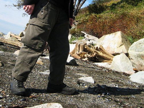
You’d think that after however many thousands of years, pants would have stopped evolving. How much can you do with a pair of pants? Apparently, if you’re Triple Aught Design, just a little bit more.
TAD Gear’s Force 10 Legionnaire Classic Cargo Pants are an amazing pair of pants. I mean it. Really. There’s pants, and then there’s TAD pants. With a really big gap in between the two. And the TAD pants are on the upper end. Way up.
The Legionnaires are made from 7.5 oz cotton “gabardine” – which is just a fancy way of saying twill (I had to look that up). (They’re also available in ripstop.) They have two front pockets, two rear pockets, two cargo pockets, and two thigh pockets.
The cargo pockets aren’t just normal cargo pockets – they’re 9” deep behemoths (that’s a Hebrew word for beast, by the way). They’re great. You could probably loose something in their abyss, but they’re somehow non-intrusive.
The two front pockets aren’t just normal pockets, either. They both sport clip reinforcements. That’s right: both sides. And they aren’t just little reinforcements on the seams, like on 5.11 pants. They’re diamonds that reinforce the whole shebang and provide a more secure hold for your pocket knife, thanks to the thicker fabric. The right front pocket also has an interior coin pocket. (Note: I’ve found that these pockets do not work with Emerson Knives’ wave opener.) I should also mention that the pockets are made of the same tough material as the rest of the pants – a welcome feature, to be sure. The first failures I always experience on pants are holes in the cheap material used to make pockets.
The back pockets are just normal back pockets. (You thought I was going to say they weren’t, didn’t you? Well, they do have the very stylish button-and-ribbon closures that are also found on the cargo pockets.)
The front of the pants have two D-rings, one on each side. Again, beating 5.11 pants by one. I really don’t know why more folks don’t put these on their pants.
Every single stress point on these pants are bartacked. All of them. There’s not a single point where reinforcements are missing. The butt is reinforced, the knees are reinforced and slightly articulated, every seam is reinforced.
The absolute best thing about these pants are the two front thigh pockets. It’s honestly hard for me to put on a pair of pants without these now. They’re a perfect fit for seemingly everything I want to put in them – cell phone, gps, camera, energy bar, notepad.
Another amazing feature – and one that makes me love TAD even more – is that the only logo on the pants (excluding the “TAD Gear green label” on the inside of the fly) is velcroed on to the right cargo pocket. Velcroed. TAD is actually giving the wearer the option of advertising for them. What other company does that? Everyone else plasters their logos all over their products and forces me to go to the trouble of cutting them off or covering them up. (TAD, Kifaru, and Arc’Teryx are usually the only companies I billboard for.)
Last June I used the uniform grant I had been given to buy a pair of TAD’s Force 10 Combat Pants (seen here on patrol) and I actually like the Legionnaires better. The Force 10’s triple reinforced knees added a good deal of heat in the sun and I didn’t find them necessary for my needs. I liked the top slot of the cargo pockets, but I found that the internal dividers would sometimes annoy me as I’d blindly reach into the pockets, groping for something, and put my hand into one of the smaller pockets instead of the main bellow. The ribbons on the cargo pocket buttons weren’t sewn down (as they are on these newer Legionnaires) and often got in the way. The one feature I really wish they’d carry over to the Legionnaires is the diamond gusseted crotch.
In case you haven’t caught on, the Legionnares are amazing pants. They’re expensive, but worth the money. Go hungry for a few days if you have to. I’ve worn these pants every day since I bought them last month, and if I had the money I’d purchase a second pair.
(MilitaryMorons, of course, has a better review, though his are a slightly older style. These new ones have a zipper fly instead of buttons and all pocket ribbons are now sewn down.)
Some people have been curious about my rolls. I started rolling my pants last year at MutantFest. I got too lazy to blouse them every day, but wanted to keep them out of the water and mud. After that, it stuck. I started riding a bike, and the rolling kept the right pant leg from getting messed up the chain. It isn’t dependent on wearing combat boots – I can do it with shorter hikers. I’ve since discovered that rock climbers roll their pants. I like to think that copying them makes other folk less excited than bloused pants with combat boots. But most of all, I keep doing it because I can refer to my rolled pants as “combat knickers”, which is a source of great amusement.
I’m back at my desk job. Classes have begun. Summer – as if a dream – has passed by and, though I’ve only been sedentary for a matter of days and I’ve enjoyed my return to this wonder-full city, my feet have begun to itch. Once more I feel the need to wander, to cast off and let the Road take me where it will.
The 5.11 Tactical Long Sleeve shirt is your average button up uniform shirt, overclocked for the more demanding user. There’s nothing to scream “shoot me first”, but one can rest assured that some measure of toughness was put into its construction, and some thought into its design.
There are two breast pockets, roughly 5.5” x 5”, which close with two velcro squares. Behind the breast pocket on either side are one of the shirt’s best features: hidden document pockets. These open vertically in the “Napoleon style” with two velcro rectangles and measure in at about 6.5” x 10”. They’re great for carrying tickets, notebooks, passports (yes, plural; you know you have more than one, you double agent you), or, if you’re one of the 5.11 models, a small firearm.
The shirt also features a vented back (one of the few areas where the observant onlooker may notice something odd about the shirt) with mesh lining, rolled-up-sleeve-holder-thingies, and two small underarm vents (read: holes) for warmer weather.
The left sleeve sports two pen slots near the top, one of which I can just squeeze a kubotan into, though it’s a little awkward.
The shirt’s elbows are reinforced and, best of all, almost every seam is triple stitched. I don’t know why practices like that aren’t more common on clothing.
Additionally, 5.11 includes two epaulets and a badge holder to be optionally sewn on the shirt.
Two logos are placed on the shirt, in addition to the neck tag: one on the bottom and one on the left cuff, both of which can be easily cut off for sanitation.
I’ve only had this black cotton shirt now for a few weeks, but have no complaints so far. It’s a well made piece of clothing that blends right in at most locations (or would blend in, had I not sewn the jolly roger on the right sleeve), but I’m not afraid to roll around in the dirt in. A perfect example of a dual use garment.
The ripstop nylon version of the shirt I’ve had since last March and have been extremely pleased. It’s slid down more than a couple cliffs and has stayed together and presentable through situations where other synthetic shirts from REI, Mountain Hardwear, and Cabelas have not. I’ve worn it comfortably up to 100F (or at least as comfortable as I was in that temperature with just a t-shirt) and often will wear it in colder temperatures over a fleece or merino mid-layer to protect those undergarments from ripping.
LAPoliceGear was kind enough to send me this shirt for review. They maintain a large stock of 5.11 products for fast shipping, all at some of the best prices on the net. (Actually, I don’t think I own a 5.11 product that I haven’t purchased from LAPoliceGear– shirts, pants, or boots.)
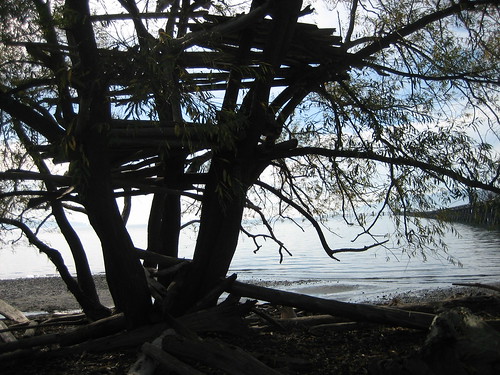
I went for a walk along the bay today. While I was climbing around in a tree house, an old man with a pipe and accordion walk underneath and asked if I slept up there. A comment on my appearance, perhaps? I don’t know, but I took it as a compliment – certainly better than the “did you use to be in the army?” comment I received last month.
(I’m holding out for the day when outdoor gear makers see the light and PALS webbing becomes common on civilian gear.)